
Page 34 - Rules of Navigation2020
P. 34
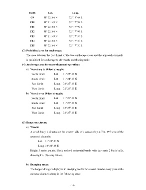
Berth           Lat.                 Long.
                           C9         31º 22’.66 N         32º 18’.68 E

                          C10         31º 21’.49 N         32º 17’.99 E
                          C11         31º 22’.08 N         32º 17’.99 E

                          C12         31º 22’.66 N         32º 17’.99 E
                          C13         31º 21’.49 N         32º 17’.30 E
                          C14         31º 22’.08 N         32º 17’.30 E

                          C15         31º 22’.66 N         32º 17’.30 E

                    (3) Prohibited area for anchorage:
                       The area between the East Limit of the two anchorage areas and the approach channels
                       is prohibited for anchorage to all vessels and floating units.

                    (4) Anchorage area for trans-shipment operations:
                       a)  Vessels up to 60 feet draught:

                           North Limit:        Lat.   31º 25’.00 N
                           South Limit:        Lat.   31º 24’.00 N

                           East Limit:         Long.  32º 27’.00 E
                           West Limit:         Long.  32º 26’.00 E

                       b)  Vessels over 60 feet draught:
                           North Limit:        Lat.   31º 27’.00 N

                           South Limit:        Lat.   31º 26’.00 N

                           East Limit:         Long.  32º 28’.00 E
                           West Limit:         Long.  32º 27’.00 E


                    (5) Dangerous Areas:

                       a)  Wreck:
                          A wreck buoy is situated on the western side of a sunken ship at Hm. 195 west of the
                          approach channels:

                                 Lat.    31º 25’.24 N
                                 Long. 32º 22’.98 E

                          Height 5 meter, painted black and red horizontal bands, with day mark 2 black balls,
                          showing FL. (2) every 10 sec.


                       b)  Dumping areas:
                          The hopper dredgers deployed in dredging works for several months every year at the

                          entrance channels dump in the following areas:


                                                            - 10    -