
Page 33 - Rules of Navigation2020
P. 33
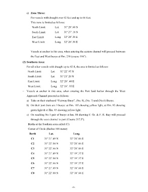
c)  Zone Three:
                          For vessels with draught over 62 feet and up to 66 feet.

                          This zone is limited as follows:
                           North Limit:        Lat.   31º 28’.60 N

                           South Limit:        Lat.   31º 27’.10 N
                           East Limit:         Long.  32º 28’.30 E

                           West Limit:         Long.  32º 26’.30 E


                          Vessels at anchor in this area, when entering the eastern channel will proceed between
                          the East and West buoys at Hm. 230 (course 194º) .

                    (2) Southern Area:

                    –  For all other vessels with draught up to 42 ft, the area is limited as follows:
                        North Limit:       Lat.    31º 22’.95 N

                        South Limit:       Lat.    31º 21’.20 N
                        East Limit:        Long.  32º 20’. 40 E

                        West Limit:        Long.  32º 16’. 95 E
                    –  Vessels  at  anchor  in  this  area,  when  entering  the  Port  Said  harbor  through  the  West

                       Approach Channel proceed as follows:
                       a)  Take on their starboard “Fairway Buoy”, (No. 8), (No. 7) and (No.6) Buoys.

                       b)  On their port there are 3 buoys: at Hm. 105 showing yellow light, at Hm. 92 showing
                          green light & at Hm. 83 showing yellow light.
                       c)  On reaching No 5 pair of buoys at hm. 80 showing F. Gr. & F. R. they will proceed

                          through the west channel to port (Course 217.5º).
                        Berths at the Southern area called (C):

                        Center of Circle (Radius 500 meter)
                         Berth           Lat.                 Long.

                           C1         31º 21’.49 N         32º 20’.06 E
                           C2         31º 22’.08 N         32º 20’.06 E

                           C3         31º 22’.66 N         32º 20’.06 E
                           C4         31º 21’.49 N         32º 19’.37 E

                           C5         31º 22’.08 N         32º 19’.37 E
                           C6         31º 22’.66 N         32º 19’.37 E

                           C7         31º 21’.49 N         32º 18’.68 E
                           C8         31º 22’.08 N         32º 18’.68 E


                                                                 - 9 -