Page 39 - Rules of Navigation2020
P. 39

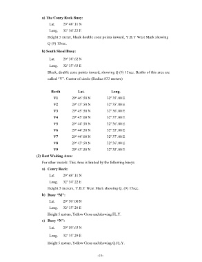
a) The Conry Rock Buoy:
                               Lat.    29º 48’.11 N

                               Long.   32º 34’.22 E
                              Height 5 meter, black double cone points inward, Y.B.Y West Mark showing

                              Q (9) 15sec.
                          b) South Shoal Buoy:


                               Lat.    29º 38’.62 N
                               Long.   32º 35’.63 E
                              Black, double cone points inward, showing Q (9) 15sec. Berths of this area are

                              called “V”. Center of circle (Radius 833 meters)


                                Berth           Lat.                Long.
                                 V1          29º 46’.50 N         32º 35’.00 E

                                 V2          29º 45’.50 N         32º 35’.00 E
                                 V3          29º 45’.50 N         32º 36’.00 E

                                 V4          29º 45’.00 N         32º 37’.00 E
                                 V5          29º 44’.50 N         32º 36’.00 E
                                 V6          29º 44’.50 N         32º 35’.00 E

                                 V7          29º 44’.00 N         32º 37’.00 E
                                 V8          29º 43’.50 N         32º 36’.00 E

                                 V9          29º 43’.50 N         32º 35’.00 E
                       (2) East Waiting Area:
                          For other vessels: This Area is limited by the following buoys:

                          a)  Conry Rock:

                               Lat.    29º 48’.11 N
                               Long.   32º 34’.22 E
                              Height 5 meters, Y.B.Y West Mark showing Q. (9) 15sec.

                          b)  Buoy “M”:
                               Lat.    29º 50’.00 N

                               Long.   32º 35’.29 E
                              Height 5 meters, Yellow Cross and showing FL.Y.
                          c)  Buoy “N”:

                               Lat.    29º 50’.63 N

                               Long.   32º 35’.29 E

                              Height 5 meters, Yellow Cross and showing Q.FL.Y.


                                                            - 15    -
   34   35   36   37   38   39   40   41   42   43   44