
Page 32 - Rules of Navigation2020
P. 32
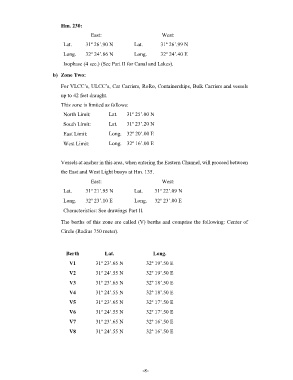
Hm. 230:
                                       East:                         West:

                           Lat.      31º 26’.90 N        Lat.       31º 26’.99 N
                           Long.     32º 24’.86 N        Long.      32º 24’.40 E

                           Isophase (4 sec.) (See Part II for Canal and Lakes).

                       b)  Zone Two:

                          For VLCC’s, ULCC’s, Car Carriers, RoRo, Containerships, Bulk Carriers and vessels
                          up to 42 feet draught.
                          This zone is limited as follows:

                           North Limit:        Lat.   31º 25’.00 N

                           South Limit:        Lat.   31º 23’.20 N
                           East Limit:         Long.  32º 20’.00 E

                           West Limit:         Long.  32º 16’.00 E


                          Vessels at anchor in this area, when entering the Eastern Channel, will proceed between
                          the East and West Light buoys at Hm. 135.
                                       East:                         West:

                           Lat.      31º 21’.95 N        Lat.     31º 22’.09 N

                           Long.     32º 23’.10 E                 Long.   32º 23’.00 E
                           Characteristics: See drawings Part II.

                          The berths of this zone are called (V) berths and comprise the following: Center of

                          Circle (Radius 750 meter).


                             Berth           Lat.                Long.

                              V1         31º 23’.65 N         32º 19’.50 E
                              V2         31º 24’.55 N         32º 19’.50 E

                              V3         31º 23’.65 N         32º 18’.50 E
                              V4         31º 24’.55 N         32º 18’.50 E

                              V5         31º 23’.65 N         32º 17’.50 E
                              V6         31º 24’.55 N         32º 17’.50 E

                              V7         31º 23’.65 N         32º 16’.50 E

                              V8         31º 24’.55 N         32º 16’.50 E


                                                                 - 8 -