
Page 102 - Rules of Navigation2020
P. 102
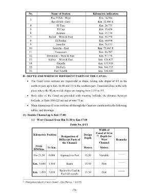
No. Name of Station Kilometric indication
Ras El-Ish - West Km. 14.304
3
Ras El-Ish - East Km. 12.800 E
4 El Tina Km. 24.775
5 El Cap Km. 35.420
6 Kantara Km. 45.130
7 Ballah – West & East Km. 54.770
8 El Ferdan Km. 64.894
9 Ismailia Km. 76.133
10 Ismailia - East Km. 75.665 E
11 Toussoum Km. 86.787
12 Deversoir – West & East Km. 97.778
13 Kabret – West & East Km. 120.827
14 Gineifa Km. 133.959
15 Shallufa Km. 146.133
16 Port Tewfik Km. 160.680
B - DEPTH AND WIDTH OF DIFFERENT PARTS OF THE CANAL:
The Canal cross sections are trapezoidal in shape, having side slopes of 4/1 in the
northern part, up to Km. 61.00 and 3/1 in the southern part. Toussoum Zone is the only
place where the Western side slopes are ranging from 2.5/1 to 3/1.
Both sides of the Canal are provided with mooring bollards, the distance between
bollards, at East (100-125 m) and at west 75 m.
Main dimensions of cross sections all through the Canal are mentioned in the following
tables, and drawings.
(1) Double Channel up to Km 17.00:
1.1 - West Channel from Hm 21.50 to Km 17.00
Table No. 4/1/1
Width of
Canal at 14 m
Kilometric Position Designation of Design (1) Depth for
Depth
Different Parts of West Remarks
the Channel Channel
From
HM/Km. To Km. Meters Meters
Hm 21.50 0.000 Approach to Port 15.50 Variable -------
Km.00.000 1.450 Basin 15.50 Port -------
Basins for Coal & -------
Km.01.450 3.650 15.50 Port
Fuel oil vessels
1 ) Navigational depth of west channel - (See Plans p. 114,115)
- 78 -