
Page 46 - Rules of Navigation2020
P. 46
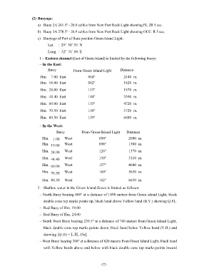
(2) Buoyage:
                       a)  Buoy 2A 281.5º - 20.9 cables from New Port Rock Light showing FL 2R 5 sec.

                       b)  Buoy 3A 278.5º - 26.9 cables from New Port Rock Light showing OCC. R 5 sec.
                       c)  Buoyage of Port of Suez position Green Island Light:

                             Lat.     :  29º  54’.59  N
                             Long.  :  32º  31’.80  E
                        1 -  Eastern channel (East of Green Island) is limited by the following buoys:

                        – In the East:
                             Buoy           From Green Island Light    Distance
                         Hm.  7.00  East             064º                2440  m.
                         Hm.  14.00  East            082º                1820  m.

                         Hm.  24.00  East            113º                1870  m.
                         Hm.  44.40  East            144º                3300  m.

                         Hm.  60.00  East            153º                4720  m.

                         Hm.  70.50  East            156º                5720  m.
                         Hm.  80.50  East            159º                6680  m.

                        – In the West:

                                  Buoy           From Green Island Light   Distance
                          Hm.   1.00   West                050º             2600  m.
                          Hm.   19.00   West               098º             1300  m.
                          Hm.   24.00   West               126º             1370  m.

                          Hm.   44.40   West               150º             3110  m.
                          Hm.   60.00   West               157º             4640  m.

                          Hm.   70.50   West               160º             5630  m.

                          Hm.  80.50   West                162º             6630  m.

                       2 -  Shallow water in the Green Island Zones is limited as follows:
                        – North Buoy bearing 000º at a distance of 1490 meters from Green island Light, black

                          double cone top marks points up, black band above Yellow band (B.Y.) showing Q.FL.
                        –  Red Buoy of Hm. 19.00

                        –  Red Buoy of Hm. 24.00
                        – South West Buoy bearing 239.5º at a distance of 780 meters from Green Island Light,
                          black double cone top marks points down, black band below Yellow band (Y.B.) and

                          showing [Q (6) + L.FL.15s].
                        – West Buoy bearing 308º at a distance of 820 meters from Green Island Light, black band

                          with Yellow bands above and below with black double cone top marks points inward


                                                            - 22    -