
Page 111 - Rules of Navigation2020
P. 111
CHAPTER VII
BUOYAGE SYSTEM IN THE CANAL
Art. 82 - Buoyage:
- Buoyage system in the Canal is according to IALA Maritime Buoyage
System Region A (Red to port)
- The navigable channel is marked by pairs of light buoys
On the East side: Green buoys showing Green Light.
On the West side: Red buoys showing Red Light.
- In the straight part, the distance between each pair is 1.5 kilometer in the north section, and 1.0
kilometer in the south section
- In the curves, ( bends ) the distance will be less than 1.0 kilometer.
- All buoys in the Canal and its approaches are fitted with radar reflectors.
- Buoys and beacons marking the Suez Canal and approach channels may be temporarily
removed, displaced or changed because of dredging or other operations.
(1)
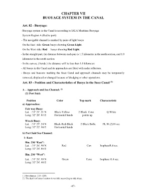
Art. 83 - Position and Characteristics of Buoys in the Suez Canal
A – Approach and Sea Channel: (2)
(1) Port Said:
Position Color Top mark Characteristic
a) Approaches:
Fair way Buoy:
Lat. : 31º 21'. 21 N Black-Yellow 2 Black Cone Q White
Long: 32º 20'. 81 E Horizontal bands points up
Wreck Buoy:
Lat. : 31º 25'. 24 N Black-Red-Black 2 Black Bolls. FL.W.(2)10 sec
Long: 32º 22'. 98 E Horizontal bands
b) Port Said Sea Channel :
1- East :
Hm. 230 “East”:
Lat. : 31º 26'. 90 N Red Can IsophaseR.4 sec.
Long: 32º 24'. 86 E
Hm. 230 “West”:
Lat. : 31º 26'. 99 N Green Cone Isophase G.4 sec.
Long: 32º 24'. 40 E
1 ) See plans p. (110 -129).
2 ) The depth at buoys location is variable according to side slope.
- 87 -