
Page 210 - Rules of Navigation2020
P. 210
N.B:
In case two vessels from different convoys pass in front of a station at the same time, the data
concerning each vessel will be displayed on the signal state board interchangeably.
nd
Meteorological data which is displayed on signal state boards (2 line) informs vessels of the
prevailing weather conditions as they pass the signal station. Also, emergency or navigation
instructions from the main management office at Ismailia can be displayed at the same line.
The displayed information is scrolled from right to left direction until it finishes then it repeats
again.
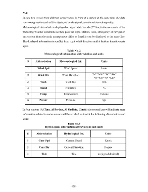
Table No. 2
Meteorological information abbreviation and units
S Abbreviation Meteorological Inf. Units
1 Wind Spd Wind Speed knots
2 Wind Dir Wind Direction "N" "NW" "W" "SW"
"S" "SE" "E" "NE"
3 Visib Visibility Km
4 Humd Humidity %
5 Temp Temperature Celsius
6 Presur Pressure hpa
In four stations (Al Tina, Al Ferdan, Al Shallofa, Ginefa) the second line will indicate more
information related to water sensors will be scrolled on it with the following abbreviations and
units:
Table No.3
Hydrological information abbreviations and units
S Abbreviation Hydrological Inf. Units
1 Curr Spd Current Speed Knots
2 Curr Dir Current Direction Degree
3 Tide Tide m (signed decimal)
- 158 -